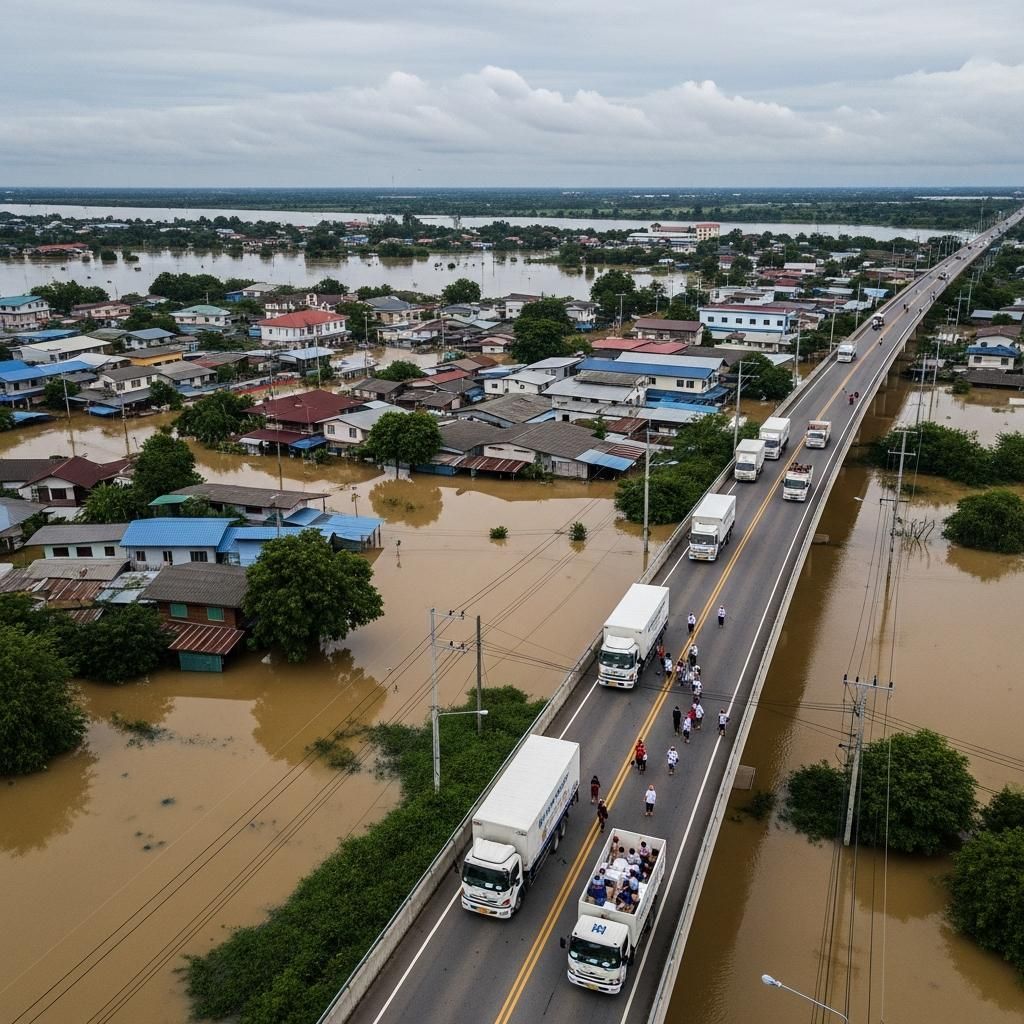
Mae Sai's next monsoon season could bring disaster if bureaucratic delays prevent the clearance of debris-choked waterways. Thailand's northernmost border town faces a perfect storm of cross-border complications, as temporary sandbags and leaking flood walls have proven insufficient against increasingly severe flash floods—and the stakes extend beyond residents to the thousands of traders, expats, and tourists who transit daily through this vital Thailand-Myanmar crossing.
Why This Matters
• Heavy thunderstorms forecast for Sunday, May 24, heightening immediate flood risk in Chiang Rai province's Mae Sai district
• Debris accumulation under the First Thai-Myanmar Friendship Bridge continues to block water flow, causing rapid water level surges that previously caused significant flooding in 2024 and early 2025
• Upstream Myanmar gold mining operations deposit thick mud residues that clog the Sai River, compounding drainage problems
• Mae Sai serves as Thailand's primary trade gateway to Myanmar, with 60,000 residents plus daily cross-border traffic making flood preparedness critical for the entire region
Waterway Obstruction Creates Recurring Crisis
The Sai River in Mae Sai district faces a compounding crisis of natural and man-made blockages that transform seasonal rains into community-threatening floods. Tree trunks, branches, and mining sediment accumulate beneath the First Thai-Myanmar Friendship Bridge, creating a bottleneck that forces water levels to rise dangerously during heavy rainfall.
Years of sedimentation from upstream Myanmar mining activities—particularly large-scale gold and rare earth extraction—have deposited thick, mud-laden residues throughout the waterway. These mining byproducts prove exceptionally difficult to remove and significantly reduce the river's capacity to handle monsoon flows. A study conducted in October 2024 identified this cross-border mining activity as a primary contributor to the recurring flood crisis.
Illegal construction along both riverbanks has narrowed the natural channel, with shops and unauthorized structures creating additional bottlenecks. This encroachment forces floodwater into residential and commercial zones that would otherwise remain dry. The Thailand Royal Irrigation Department identified these structures as priority removal targets in planning documents from early 2025, yet clearance operations remain incomplete.
Demolition Timeline Stalls Despite Urgent Need
Myanmar authorities completed most demolition work on their side of the border by March 2025, progressing quickly with both structure removal and construction of a new reinforced wall. Thai officials, meanwhile, continue awaiting final authorization to complete parallel clearance operations initially scheduled for completion between March and April 2025.
The Chiang Rai Provincial Government ordered encroachers to remove illegal structures along the Sai River in April 2025, setting a deadline of June 20, 2025, to facilitate construction of a reinforced flood embankment. While that embankment work proceeded to completion by mid-2025, the comprehensive debris removal and river dredging operations have encountered regulatory delays that push critical maintenance into the 2026 monsoon season.
Thailand's Water Resources Department has not announced a specific timeline for resuming large-scale clearing operations in 2026, leaving residents uncertain whether the waterway will be adequately prepared before peak flooding season arrives in late summer.
What This Means for Border Residents
Mae Sai residents and cross-border commuters face an elevated threat level as the district enters a period of forecasted heavy rainfall. Cloudy conditions with light rain dominate the immediate forecast, but meteorological services predict heavy thunderstorms beginning Sunday, May 24, followed by scattered thunderstorms throughout the following week.
The district's vulnerability stems from multiple converging factors: persistent heavy rainfall causes the Sai River to overflow its banks rapidly, creating flash floods in riverside communities and on public roads. Inadequate drainage systems—a byproduct of rapid, unplanned urbanization—cannot manage the surface runoff from severe weather events, diminishing the land's natural water absorption capacity.
Critical cross-border concern: Thai authorities are still assessing the detailed impact of a high flood barrier recently constructed on the Myanmar side near the border crossing as of May 21, 2026. This structure could potentially redirect water flow toward Thai communities—a serious issue that may affect both property damage and the future viability of the Thailand-Myanmar Friendship Bridge crossing during severe floods.
Temporary sandbag barriers near the bridge have repeatedly failed to withstand massive water flows during severe flooding events, and even the permanent flood walls constructed in 2025 show vulnerability, with reports indicating water seepage through the structures during peak flows.
Practical Guidance for Mae Sai Residents and Travelers
Given Mae Sai's importance as Thailand's primary trade gateway to Myanmar, flood preparedness requires attention from both permanent residents and regular cross-border users:
Evacuation and Travel Planning:
• Primary evacuation routes lead south toward Chiang Rai city (approximately 50 kilometers). Monitor conditions closely if you depend on the Thailand-Myanmar Friendship Bridge for daily commute or business
• During severe flood warnings, the border crossing may temporarily close, potentially trapping travelers and disrupting commercial traffic. Check updates before travel
• Secondary routes through Mae Sot (Tak Province) or Mae Sai's elevated interior roads remain options during closures
Real-Time Flood Information:
• Download the "Usurapong" smartphone application for location-specific weather and water level alerts in Thai and Myanmar languages
• Follow Thailand Meteorological Department updates: www.tmd.go.th
• Contact Mae Sai District Emergency Center: +66 (0) 53-733-044 for immediate flood advisories
Local Resources:
• Emergency shelters open at district schools and temples during severe flooding
• Mae Sai Hospital (+66 (0) 53-731-056) maintains emergency services during floods
• Register with your local tambon (subdistrict) office for evacuation coordination
Lessons from Successful Thai Flood Management
Other provinces have implemented innovative solutions that offer potential models for Mae Sai's flood crisis—and importantly, some approaches are now being considered for cross-border application. Sukhothai Province, which faces repeated flooding from the Yom River, has piloted environmentally friendly "Kankyo" revetment blocks through collaboration with Japanese engineering firms. These blocks provide long-lasting erosion control and embankment protection, significantly reducing repair costs and flood damage over time.
The Bang Rakam model, implemented along the lower Yom River and benefiting Sukhothai city, recreates semi-natural floodplains that divert and manage excess water, successfully reducing downstream flooding. This nature-based approach has proven more sustainable than purely engineered solutions and could be adapted to Mae Sai's river management strategy.
A $17.53M project across Phitsanulok, Sukhothai, and Uttaradit focuses on restoring old river channels for natural drainage and reinforcing riverbanks with mangroves and vegetation. This nature-friendly management of the Yom and Nan Rivers builds long-term resilience for farming communities while improving water flow. These concepts are directly transferable to Mae Sai's situation, where vegetation-based embankment reinforcement could complement the existing concrete flood walls.
Mae Sai Municipality has already made progress in early warning systems, upgrading beyond an inadequate siren system to include the smartphone application "Usurapong" that provides location-specific weather and water level advisories in both Thai and Myanmar languages—critical for the district's bilingual border population. This positions Mae Sai ahead of many Thai provinces in preparedness technology.
Bangkok's experience with illegal housing blocking key drainage canals like Khlong Prem Prachakorn offers another instructive case. The capital addressed this challenge by offering residents relocation to new housing projects, allowing for canal widening and embankment construction—a model that Thai authorities could adapt for Mae Sai's riverbank encroachment problem, though cross-border coordination would add complexity.
Immediate Preparedness Measures
Provincial governors across northern Thailand have received instructions to prepare for potential flooding, coordinate with local administrations, and warn residents in at-risk areas. The Thailand Meteorological Department continues issuing warnings for flash floods and overflowing waterways throughout the region.
The construction of a floodwall along the Sai River and a flood levee in Mae Sai, which reached completion in June 2025, represents the most significant recent infrastructure improvement. However, these structures function as last-resort defenses rather than comprehensive solutions to the underlying waterway capacity problems.
Upstream hydropower dam management remains another variable factor. Poor coordination of water releases from dams located upstream can contribute to and worsen downstream flooding in Mae Sai, necessitating better communication protocols between dam operators and district authorities.
The convergence of cross-border mining impacts, incomplete demolition work, and forecasted severe weather creates a scenario where Mae Sai enters the coming monsoon season with inadequate defenses. Whether temporary measures and existing infrastructure can withstand the next major flood event remains the critical question for the district's 60,000 residents—and a concern that extends to the thousands of daily cross-border traders and travelers who depend on this vital Thailand-Myanmar gateway.