The Thailand Regional Irrigation Office 1 has delivered on a promise that many in Chiang Mai feared would slip away—a reinforced Ping River barrier will be operational by late May, providing protection before monsoon rains intensify in Northern Thailand in mid-June. This represents genuine infrastructure momentum in a region that has endured catastrophic water damage twice in the past three years.
Why This Matters
• Operational timing: The upgraded flood wall becomes active by late May 2026, providing four months' buffer before monsoon intensity peaks in August-September
• Defensive capacity: The structure reaches 5.20 meters in height and manages flows up to 800 cubic meters per second
• Geographic protection: Direct safeguards now extend across 303 meters downstream of the Tha Wang Tan Watergate, primarily sheltering Saraphi and Pa Daet districts along with riverside commercial zones
The Precedent: Why Infrastructure Matters Now
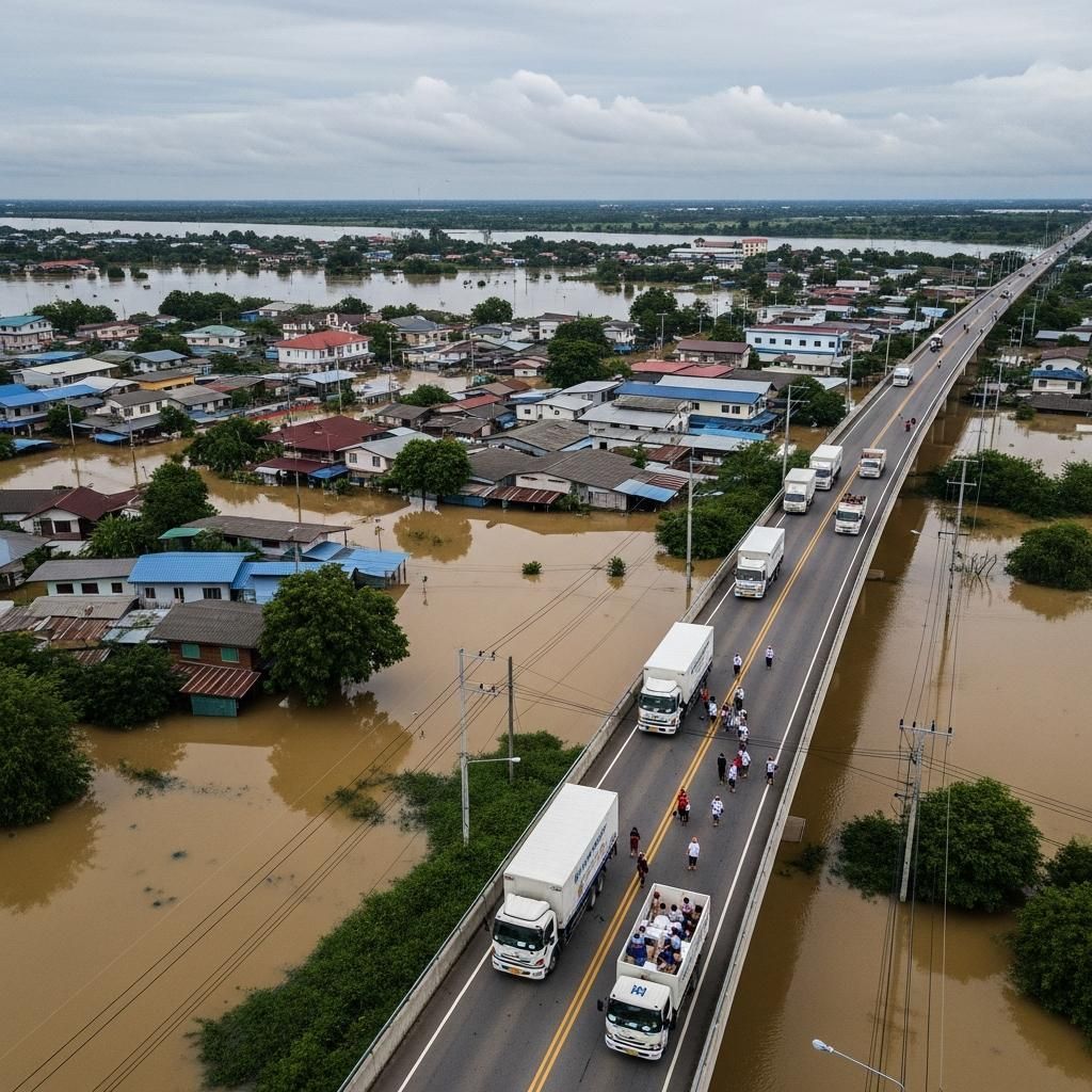
Residents who lived through October 2024 need no convincing that robust barriers save lives and livelihoods. That month, the Ping River breached older levees with a ferocity that locals describe in superlatives—the worst flood in 50 years, according to hydrological records. Water levels peaked at 5.3 meters on the night of October 5-6, surpassing any prior documented measurement in half a century of monitoring. For residents experiencing their first monsoon in Chiang Mai, it was unprecedented. For older residents, it was the worst they had witnessed.
The human consequences materialized quickly. At least 3 people died in Chiang Mai proper—including electrocutions and mudslide fatalities—while the broader Northern Thailand flood zone recorded significantly higher tolls. Over 100,000 people were displaced regionally. Chiang Mai's Warorot Market and Muang Mai Market, historic commercial hubs where generations of traders have conducted business, remained submerged for weeks. Sanctuaries evacuated more than 100 elephants; two animals drowned in the chaos.
Economically, the 2024 inundation left 10 billion baht in damage within Chiang Mai basin alone. The broader Northern Thailand aggregate exceeded 60 billion baht. When waters retreated, cleanup crews discovered 15-centimeter layers of sediment coating streets and storefronts near the river—a brownish residue requiring industrial-scale removal operations. Farmers watched seedbeds, standing crops, and livestock vanish. Agricultural losses regionally reached approximately 10 billion baht.
The Incomplete Recovery: 2025's Reminders
The 2025 wet season failed to offer the reassurance many sought. Although Chiang Mai city escaped the broad devastation of 2024, peripheral zones experienced predictable vulnerability. Tropical Storm Wipha in late July-early August affected nearly 300,000 people across 12 northern provinces. In Chiang Mai, the Chang Khian community of Mueang District bore concentrated damage—50 households and 185 residents endured inundation, though fortunately without fatalities.
August delivered flash flooding across outer districts: Mae Chaem, Mae Rim, Galyani Vadhana, and San Pa Tong each reported significant impacts. Two bridges washed away in Mae Chaem; some villages reported water depths exceeding one meter. By September, discharge from the Mae Ngad Somboonchon Dam upstream pushed the Ping River toward critical thresholds again. The cumulative lesson was stark: only Chiang Mai's central zones protected by existing dikes possessed genuine security. Anything beyond that perimeter—tributary streams, lower elevation districts, agricultural expanses—remained exposed to hydrology that no amount of community resilience could counterbalance without hard infrastructure.
The Engineering Response Takes Shape
Under the supervision of Mr. Atthawit Nakwatchara, Director of the Thailand Regional Irrigation Office 1, engineers have executed a straightforward but substantial upgrade. The original 3.70-meter barrier has been raised by an additional 1.50 meters, yielding a new height of 5.20 meters. Simultaneously, the structure has been extended to span 303 meters in total length. This reinforced corridor now carries a design specification of 800 cubic meters per second—a flow threshold that translates into practical terms. At this capacity, the barrier manages water volumes equivalent to filling roughly 150 Olympic-sized swimming pools every 24 hours.
The project was originally scheduled for September 2026 completion. Early finish by late May means final concrete pours, backfill, and landscaping can conclude before June rains arrive. Monsoon cloudbursts during late-stage construction would compromise uncured concrete, halt work rhythms, and expose the project to weather damage. The four-month acceleration reflects not optimism but pragmatic sequencing—finish the physical infrastructure before the climate makes further work impossible.
That said, no barrier operates in isolation. The 800 m³/s design assumes upstream dam operators manage the Bhumibol Dam in the upper Ping basin responsibly and that rainfall intensity remains within historical parameters. If tropical cyclone frequency increases due to long-term climate shifts, or if the 2026 monsoon proves exceptionally intense, even this upgraded wall faces theoretical stress. But for residents accustomed to uncertainty, the wall provides a quantifiable engineering margin that did not exist in 2024.
Layered Defense: Technology Complements Concrete
The flood wall anchors a more sophisticated defensive ecosystem that combines conventional engineering, digital monitoring, and nature-based interventions.
Real-Time Alert Systems: Chiang Mai University's Climate Change Data Centre has deployed FloodBoy, an AI-powered network of automatic water-level sensors feeding real-time alerts to mobile devices across high-risk zones throughout the northern region. The system generates predictive models designed to provide emergency managers several hours of advance warning rather than minutes. That margin can determine whether evacuation remains orderly or descends into chaos. Registration is free and accessible within minutes; coverage extends across multiple northern provinces, making it practical self-insurance for any resident or business owner.
Infrastructure Layers: In November 2025, dredging operations completed clearance of the Ping River channel, reducing flow resistance and improving water conveyance. Earlier, in early 2025, contractor TERRATEC finalized boring a 256-meter drainage tunnel for the Chiang Mai Flood Mitigation Project Phase 2. This underground corridor redirects excess stormwater away from congested urban neighborhoods, functioning as an unseen bypass during heavy rainfall events. The Mueang Chiang Mai Municipality has stockpiled sandbags, water pumps, and personnel while reinforcing levees in commercial districts.
Natural Detention Basins: The innovative "Kaem Ling" (monkey cheeks) project commandeers low-lying paddies as temporary water detention zones during extreme rainfall, mimicking natural wetland function and reducing strain on artificial drainage systems. Upstream, reforestation initiatives show measurable potential; research suggests that substantially increased tree cover across the Ping River watershed could reduce peak flood flows by double-digit percentages.
Who Benefits Most—And Who Remains Exposed
The upgraded barrier's most direct benefit accrues to property owners in Saraphi district and Pa Daet subdistrict—specifically, properties within the 303-meter protected corridor downstream of the Tha Wang Tan Watergate. Riverside businesses that experienced multi-week closures and inventory devastation in 2024 now face reduced operational risk, though prudent operators will maintain evacuation protocols regardless.
Farmers occupy a more complex position. Predictable drainage and controlled dam releases mean seedbeds are less likely to sit under stagnant water during the critical June-July window when rice or secondary crops must establish root systems. Yet benefits concentrate in directly protected areas. Farmers on tributary streams or in non-protected outer districts remain exposed despite the upgraded wall. Their resilience depends on additional interventions—localized levees, private flood barriers, or elevation strategies.
For expatriates and property investors, due diligence requires confirming location specificity. Addresses immediately downstream of the watergate enjoy maximum direct benefit. Properties farther north, on tributary channels, or in outer districts require enhanced risk assessment—perhaps secondary barriers, elevated construction, or flood insurance that genuinely reflects local exposure.
Flood insurance economics may shift as well. Premiums spiked dramatically after October 2024's devastation. If insurers recognize the new 800 m³/s design capacity and adjust risk models accordingly, premiums may stabilize or decline for properties within the protected corridor. However, properties outside this zone should anticipate that premiums reflect genuine ongoing exposure.
What Residents Should Do Now
The completion of the flood wall is significant, but preparation remains essential. Here are the most important steps you can take:
Confirm Your Protection Status: Residents can determine if their property falls within the protected zone by contacting the Thailand Regional Irrigation Office 1 or the Mueang Chiang Mai Municipality. Ask specifically if your address lies within the 303-meter corridor downstream of the Tha Wang Tan Watergate. This confirmation should directly influence your insurance and preparedness planning.
Register for FloodBoy Alerts: Access Chiang Mai University's FloodBoy system to receive real-time water-level alerts on your mobile device. Registration is free and typically takes minutes. This system provides advance warning of critical water levels, giving you hours to secure valuables, move vehicles, or evacuate if necessary. For residents outside the protected corridor, this warning system is particularly valuable.
Review Your Flood Insurance: Contact your insurance provider to discuss how the upgraded barrier might affect your coverage. Properties within the protected corridor may see premium reductions as risk models adjust. If you're outside the protected zone, ensure your policy reflects actual exposure and includes coverage for contents as well as structure.
Plan for Your Specific Zone: If your property is outside the protected corridor—particularly on tributary channels or in outer districts like Mae Chaem, Mae Rim, or San Pa Tong—consider supplementary protection measures: secondary barriers, elevated storage for valuables, or modifications to your property's drainage and foundation. The regional irrigation office can advise on solutions tailored to your location.
Stay Informed Through June-September: Monitor forecasts during monsoon season. Even with the new barrier, individual vigilance combined with technology alerts provides the most comprehensive protection.
Climate modeling suggests monsoon intensity may increase across coming decades, meaning even upgraded barriers could eventually face stress. What the project guarantees is that Chiang Mai enters the 2026 wet season with substantially more infrastructure capacity than in October 2024. For residents, farmers, and business owners conditioned by recent devastation, that represents provisional but genuine resilience—an engineering response proportional to a region where water defines both prosperity and catastrophic loss.