Sandbars Replace Waterway: How the Mekong's Dramatic Shrink Reshapes Life Along Thailand's Northeast Border
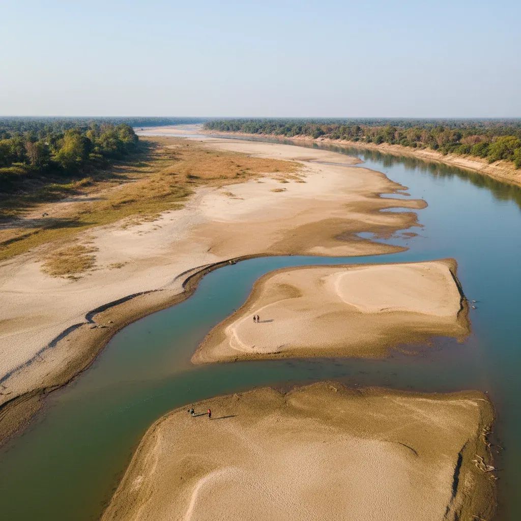
The Mekong River along Thailand's northeastern frontier in Nong Khai Province has become so shallow that residents now walk to Laotian islands on exposed sandbars—a transformation that raises urgent questions about water scarcity, livelihood collapse, and the geopolitical forces reshaping one of Asia's most vital waterways.
Why This Matters:
• Water level dropped to 1.37 meters—more than 7 meters below safe operating thresholds—transforming river navigation into walking paths.
• Fishing income crashed from ฿200,000–300,000 annually to as little as ฿5,000 for some households, forcing communities to choose between poverty and migration.
• 11 upstream dams now control the Mekong's flow; China and Laos release water based on power generation needs, not seasonal cycles communities depend on.
When the River Becomes Land
The shift happened gradually, then suddenly. The Nong Khai Hydrology Unit, part of Thailand's Department of Water Resources, recorded measurements in late February showing dramatic declines. At 1.37 meters—equivalent to a shallow swimming pool—the Mekong became something it never was before in this region: navigable by foot.
Near Ban Mo village in Si Chiang Mai district, families strolled to Don Ching Choo, a Laotian-administered sandbar island where local farmers cultivate crops. The journey that once required a boat now takes a casual walk across compacted sand. In other stretches, fishermen waded waist-deep into exposed riverbed, spearing what remained of the catch by hand. Sports-minded locals discovered another use for the newly exposed flats: volleyball courts and running tracks where water once flowed.
This has become routine out of necessity.
The Machinery Behind the Crisis
The Mekong's collapse stems from a layered catastrophe: seasonal drought intensified by climate change, 11 large-scale hydroelectric dams controlling upstream flows, and a fundamental mismatch between when water is needed and when infrastructure allows it to flow.
China's Manwan Dam, which came online in 1996, was the first. It began a pattern replicated across the upper Mekong: vast reservoirs capturing water during rainy seasons to maximize dry-season power generation. The result works perfectly for electricity—less perfectly for farmers and fishermen downstream whose cycles demand the opposite timing.
Thailand's rising temperatures—official onset of summer season means accelerated evaporation—exacerbate what upstream infrastructure already set in motion. The Mekong River Commission (MRC), a multinational body tracking basin-wide data, confirmed that sediment loads have plummeted by 90% in some tributaries as dams trap nutrient-rich silt. The water appears unusually clear—a visual change that indicates ecological damage. Suspended sediment is not waste; it is the foundation of aquatic breeding cycles and riverbank renewal.
The flow is no longer seasonal monsoon rhythm. It is engineered pulse, determined by power demand curves in distant control rooms.
Fishing Communities Face Economic Freefall
The immediate human toll plays out in daily income collapses. Nong Khai's fishing households historically earned ฿200,000–300,000 annually—a livable sum in the region. Catch volumes have evaporated alongside water levels. Some fishermen now gross ฿5,000 yearly, a 97% decline. Certain fish species have disappeared entirely. Shrimp and shellfish populations, which once sustained secondary industries in processing and trade, have dwindled to scarcity.
Navigation hazards mount. Commercial cargo vessels moving goods between Thailand and Laos face impossible choices: reduce payload to dangerous levels, divert routes (raising costs prohibitively), or anchor until conditions improve. Dock workers and transport laborers lose wages when these delays accumulate into weeks.
Cage aquaculture operators—farmers raising fish in confined pens—confront seasonal relocation. When water recedes, viable pens retreat with it, sometimes leaving no adequate depth anywhere nearby. Equipment relocation costs and downtime losses mount rapidly.
When Water Taps Go Dry
The Provincial Waterworks Authority in Nong Khai struggles with a more immediate problem: municipal supply systems cannot reach receding water. Intake pipes designed for historical river depths no longer reach functioning channels. Pumping stations require floating platforms to stay operational. Emergency pipes extend farther into the riverbed, adding friction, cost, and unreliability.
In affected villages, tap pressure weakens or ceases. Water trucks become lifelines, distributing portable supplies to neighborhoods disconnected from municipal systems. This temporary solution masks a permanent shift: if Mekong levels remain suppressed, infrastructure—dams, reservoirs, treatment facilities—designed for different conditions will require complete overhaul.
Agricultural irrigation faces similar hydraulic nightmares. Farmers with riverbank plots cannot lift water to their fields; pumps designed for historical depths now run dry or overstress. Crops wither. Seasonal income evaporates.
The Dam Question: Who Decides When Water Flows?
The Thailand National Water Resources Office and Laos Ministry of Natural Resources and Environment signed a Memorandum of Understanding on Integrated Water Resource Management on October 8, 2024, witnessed by both nations' prime ministers. The accord creates mechanisms for information exchange, disaster preparedness coordination, and climate adaptation planning.
A Joint Committee for Management on Mekong River and Heung River (JCMH)—comprising Thailand's Department of Public Works and Town & Country Planning and Laos' Department of Waterways—sets technical standards for riverbank reinforcement and sand dredging to minimize cross-border environmental damage.
Both governments are drafting a five-year action plan (2024–2029) addressing early warning systems, livelihood diversification schemes, and collaborative research. Thailand has pledged funding for early warning stations on tributary streams in Laos, aiming to improve both nations' flood-and-drought forecasting capabilities.
Yet critical opacity remains. Upstream dam operators—particularly Chinese facilities—rarely share release schedules in advance. Local advocacy groups throughout Thailand's northeastern border region have demanded mandatory public participation in major water management decisions and stronger environmental impact assessment enforcement before new hydroelectric projects receive approval.
The question is not whether cooperation exists; it is whether cooperation can override the fundamental asymmetry: nations controlling upstream infrastructure have no reciprocal obligation to prioritize downstream survival.
Short-Term Patches for a Long-Term Wound
Nong Khai's provincial government established a temporary water command center monitoring river conditions and coordinating emergency response. Measures include water truck distribution to disconnected villages, emergency dredging permits for waterworks intake channels, temporary retention ponds constructed along riverbanks to capture whatever water is captured, and direct cash assistance to fishing households facing subsistence-level income collapse.
The Nong Khai Chamber of Commerce petitioned central government for urgent compensation, warning that cumulative provincial economic damage could exceed several hundred million baht if suppressed conditions persist through summer.
These are palliatives. They address immediate crises, not underlying vulnerabilities.
When the Mekong Stops Being a River
What residents of Nong Khai and neighboring northeastern provinces are witnessing is not a temporary drought. It is a structural realignment: the Mekong is increasingly governed by non-natural flow regimes shaped by infrastructure and climate disruption rather than monsoon cycles.
Thailand's Office of National Water Resources projects that dry-season water deficits will intensify over the next decade, driven by continued upstream dam construction and erratic rainfall tied to global atmospheric change. The walkable sandbars visible today prefigure a new hydrology: a river subordinated to energy grids and investment returns, its rhythm no longer a gift of seasonal rains but a byproduct of distant engineering decisions.
For communities along Thailand's northern border, this represents a quiet unraveling of centuries-old adaptation. The Mekong was source of food, transport, cultural identity, and predictable livelihood. Now it swings between extremes—floods that arrive unpredictably, droughts that linger beyond historical norms—its rhythms decoupled from the communities whose survival depends on them.
Bilateral cooperation between Thailand and Laos offers necessary foundation, but meaningful progress demands sustained transparency from all basin countries, particularly China's upstream operations. It requires investment in genuinely resilient alternatives for millions dependent on Mekong fisheries and agriculture—not temporary cash transfers but economic restructuring. Most fundamentally, it requires acknowledging that engineering and climate pressures have fundamentally altered what the Mekong is and what it can provide.
In the meantime, residents walk across sandbars where water used to flow, improvising solutions to a crisis that international agreements and water management committees show few signs of solving.